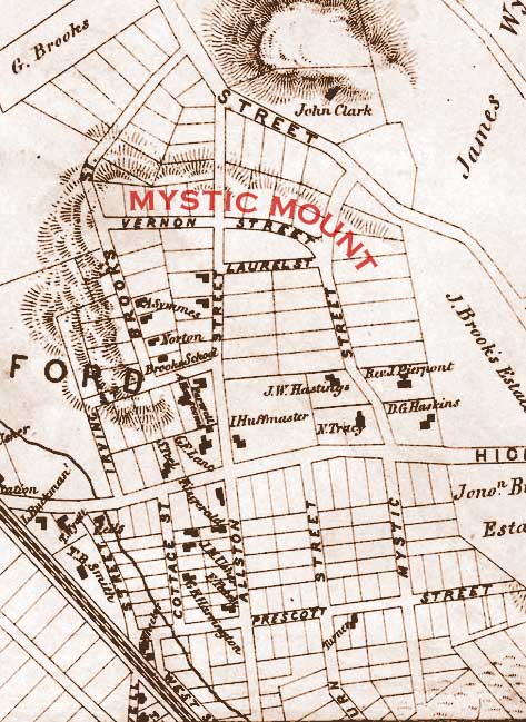
MYSTIC MOUNT
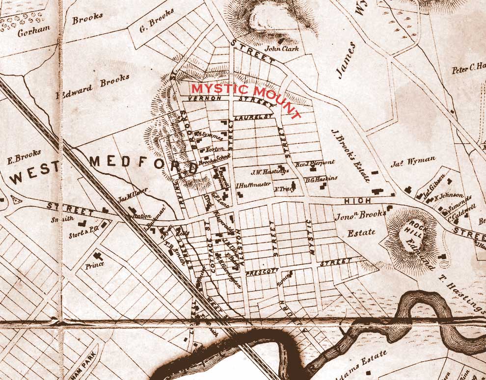
“Mystic Mount” is the former name for a hill (now known as “Hastings Heights”) sloping up from the banks of the Mystic River where it winds through the western portion of Medford, Massachusetts. Several old accounts of this hill give a flavor and a sense of the history associated with the part of town within which it lies.
Brooks, Charles, History of the Town of Medford, Middlesex County, Massachusetts, from its First Settlement, in 1630, to the Present Time, 1855 (Boston: James M. Usher, 1855)
The next highest and most interesting spot, on the north side of the [Mystic] river, is “Mystic Mount,” in West Medford, near the Brooks Schoolhouse. It is owned by the town, and commands much the same view as Pine Hill, only at a lower angle. To some of us who have kept it for more than half a century, as our favorite look-out, it has charms indescribably dear, and we regard it somewhat as we do an ancient member of a family.
Bacon, Edwin M., Walks and Rides in the Country Round About Boston – Copyright 1897 by the Appalachian Mountain Club (Boston: Houghton Mifflin and Company, 1900)
Our West Medford walk will be a short one, The quarter lies somewhat removed from Old Medford, with which it is connected by an electric line along High Street, and is directly approached from Boston by the main line of the Boston and Maine Railroad, Southern Division. …
If we choose, we may take the electric car passing through this tree-embowered thoroughfare [High Street], but by doing so we would miss the heights at the right, finishing in old Mystic Mount, long a favorite outlook with old Medfordians, which, as Brooks wrote, was regarded by them somewhat as an “ancient member of a family.” This is now a little public park, bearing the name of “Hastings’s Heights.” We may reach it through side streets at the right, – directly by the street next below Mystic Street [Allston Street]. Its narrow rocky summit affords a pleasant view, but not so extensive and satisfactory as it would be were the near-by houses less obtrusive. From this park we should strike for the valley by way of Vernon Street on the further side, bearing to the left and crossing by a footpath over the fields below, to the roadway close up to the station. For the beautiful trees adorning the older West Medford streets east of the railroad track, the inhabitants are indebted to the late Edmund T. Hastings, formerly of Cambridge, who personally superintended the setting out of them.
Medford Past and Present – 275th Anniversary of Medford, Massachusetts, June, 1905 (Medford: Medford Mercury, 1905)
The West end is a residential section. In 1870, it had but one store, a grocery, then but a few years established. At the present writing [1905] there are nearly forty.
Mattresses on which quiet slumbers may be had are made here1, and granite doorsteps for the houses of the living, and tombstones and monuments for the dead, are also made. and have been for fifty years. Two livery and boarding stables supply good teams, and if your auto gets cranky and refuses to move, that can be made to do so just off from High street. These, and the various tradesmen that build the dwellings and keep them in repair, form the local business contingent, therefore West Medford is residential. Men go elsewhere (and women, too) to toil and accumulate, and return here to enjoy the results of their labor — to live. The steam railway, whose equipment and service would astonish its projectors could they return to it, and the two divisions of the great electric system make this possible. Good roads, well kept, occupy the place of the ancient ways, and new ones are opened as occasion requires.
Take a stroll on Allston street, and ascend the hill, — the "Mystic Mount" of fifty years ago. "Hastings Heights" is the official name it now bears. Walk slowly, save your breath, and take in the scene. Walk up the steps, or take the easier path around. There is the old flag-staff, a mast of a Medford-built ship, after traversing many seas, and located once in Old Medford, then again near Mystic Hall, for over thirty-five years has stood here on good foundation, the solid rock, and bears aloft the bird o' freedom and Old Glory.
Now ascend the stone tower2 and look, and what a cyclorama is about you, only rivalled in Medford by that from the Lawrence tower. Northward stretch the Fells, an unbroken sea of foliage, and the nearer hills of our own northern boundary, in whose valley and on whose wooded slope is the silent city — Oak Grove. Beyond is the tapering spire and glistening cross of Winchester Church. Westward, the Mystic lakes, and the wooded hills beyond, stretching away to the heights of Arlington, across the valley up which the British marched once and back again. Trace its course by the smoke of the locomotive as it climbs the hills. Southward and toward the east, spire after spire, the gilded dome of the State House, and the granite shaft of Bunker Hill, and the lofty chimneys, and the long bridges. On Medford's southern border, and overlapping a little into Somerville, the growing cluster of Tufts College buildings. Now follow the course of the Mystic, encircling the west end. Since time began, its waters have restlessly flowed both ways, and for years have borne away the many ships built upon its banks. Ere long it will be said of it: “There shall be no more sea," and the tides will come no more. But broader, deeper and more beautiful will it be when the work of the Park Commission, already begun, shall have been completed.
Below, on every side, lies the subject of our sketch, grown in thirty-five years from a village of less than one hundred houses, with a possible population of five hundred, to well nigh five thousand at the present view. Seen from this vantage point, it may well be called the Forest City. On this anniversary day it is a waving mass of green, in which many of the residences and streets are hidden, of the various churches, only the great open tower and shining cross of Trinity is visible. Where once the canal boats crept slowly along, the trolley car moves rapidly, but goes not beneath the granite arch built eighty-five years ago and still preserved on the Brooks estate.
________
1 West Medford was the home of several mattress factories during the 19th and well into the 20th centuries. The last factory, a Simmons Beautyrest factory, closed in 1978.
2 Around 1900, a tower was erected by the City Parks and Recreation Department at the pinnacle of Hastings Park, the former Mystic Mount. Made of water-washed rocks salvaged from a stone retaining wall which was being replaced around the park, this tower (sometimes erroneously thought to be a Revolutionary War-era powder house or signal tower) still exists, but can no longer be climbed.
Mann, Moses Whitcher, West Medford in 1870 – Medford Historical Register Volume 8 No. 4 (Medford: Medford Historical Society, 1905)
As the train moved along the view of these was quickly broken by the seamed and scarred promontory of Rock Hill, where once was the home of Nanepashemit, and which commanded a view of the river in either direction. No bridge spanned the river at Auburn street as now, but the disused canal, innocent of water, was plainly visible before reaching the loop in the river near the mouth of Whitmore Brook, where once a ship was built and launched. Scattered here and there on the gentle slope from High street to the river, and on the steeper side of Mystic Mount were some fifty dwellings in 1870, among which the Brooks schoolhouse stood sharply out as a central figure. These formed the bulk of the West End — the West Medford of 1870.
Mann, Moses Whitcher, How Medford Began to Grow – Medford Historical Register Volume 14 No. 1 (Medford: Medford Historical Society, 1911)
In 1855 historian Brooks alluded to several ‘outlays’ of ‘townships’ in Medford, with commending words for each. The names he recorded were Bellevue, Sagamore Vale, Williamsburg and Wellington. He said, ‘Private gentlemen open roads through their grounds, mark off many acres into small lots, publish a map of the unborn city, and on the appointed day begin to sell the little enclosures at public auction.’
Now that fifty-five years have passed, and with them the promoters of these enterprises, it may be of interest to note the development of the ‘outlays.’
The first named, and perhaps the earliest, was by Messrs. E. T. Hastings and Samuel Teel. Mr. Brooks placed it in 1845, and styled it a ‘beneficence.’ It comprised nearly all the area between Rock Hill, the river and the Lowell railroad, and included Mystic Mount, now known as Hastings Heights. Ten streets were within its limits, and the record says that in nine years thirty-five houses were built thereon. An observant person can easily identify these today, and of many of them speak in praise of their builders. A few have been moved to other positions, some remodeled, and nearly all remain.
These gentlemen planned wisely, and in planting elm trees along their streets created vistas of beauty. Somebody is entitled to praise for selecting in a central position a generous lot, bordered by three streets, for the Brooks School site.
It took over thirty years for people to realize that the rocky eminence now crowned by the stone tower was ‘beautiful for situation,’ but during that time an enterprising ‘township’ had grown.
“Mystic Mount” is the former name for a hill (now known as “Hastings Heights”) sloping up from the banks of the Mystic River which winds through Medford, Massachusetts. Several old accounts of this hill give a flavor and a sense of the history associated with the part of town within which it lies.
Brooks, Charles, History of the Town of Medford, Middlesex County, Massachusetts, from its First Settlement, in 1630, to the Present Time, 1855 (Boston: James M. Usher, 1855)
The next highest and most interesting spot, on the north side of the [Mystic] river, is “Mystic Mount,” in West Medford, near the Brooks Schoolhouse. It is owned by the town, and commands much the same view as Pine Hill, only at a lower angle. To some of us who have kept it for more than half a century, as our favorite look-out, it has charms indescribably dear, and we regard it somewhat as we do an ancient member of a family.
Bacon, Edwin M., Walks and Rides in the Country Round About Boston – Copyright 1897 by the Appalachian Mountain Club (Boston: Houghton Mifflin and Company, 1900)
Our West Medford walk will be a short one, The quarter lies somewhat removed from Old Medford, with which it is connected by an electric line along High Street, and is directly approached from Boston by the main line of the Boston and Maine Railroad, Southern Division. …
If we choose, we may take the electric car passing through this tree-embowered thoroughfare [High Street], but by doing so we would miss the heights at the right, finishing in old Mystic Mount, long a favorite outlook with old Medfordians, which, as Brooks wrote, was regarded by them somewhat as an “ancient member of a family.” This is now a little public park, bearing the name of “Hastings’s Heights.” We may reach it through side streets at the right, – directly by the street next below Mystic Street [Allston Street]. Its narrow rocky summit affords a pleasant view, but not so extensive and satisfactory as it would be were the near-by houses less obtrusive. From this park we should strike for the valley by way of Vernon Street on the further side, bearing to the left and crossing by a footpath over the fields below, to the roadway close up to the station. For the beautiful trees adorning the older West Medford streets east of the railroad track, the inhabitants are indebted to the late Edmund T. Hastings, formerly of Cambridge, who personally superintended the setting out of them.
Mann, Moses Whitcher, West Medford in 1870 – Medford Historical Register Volume 8 No. 4 (Medford: Medford Historical Society, 1905)
As the train moved along the view of these was quickly broken by the seamed and scarred promontory of Rock Hill, where once was the home of Nanepashemit, and which commanded a view of the river in either direction. No bridge spanned the river at Auburn street as now, but the disused canal, innocent of water, was plainly visible before reaching the loop in the river near the mouth of Whitmore Brook, where once a ship was built and launched. Scattered here and there on the gentle slope from High street to the river, and on the steeper side of Mystic Mount were some fifty dwellings in 1870, among which the Brooks schoolhouse stood sharply out as a central figure. These formed the bulk of the West End — the West Medford of 1870.
Medford Past and Present – 275th Anniversary of Medford, Massachusetts, June, 1905 (Medford: Medford Mercury, 1905)
The West end is a residential section. In 1870, it had but one store, a grocery, then but a few years established. At the present writing [1905] there are nearly forty.
Mattresses on which quiet slumbers may be had are made here1, and granite doorsteps for the houses of the living, and tombstones and monuments for the dead, are also made. and have been for fifty years. Two livery and boarding stables supply good teams, and if your auto gets cranky and refuses to move, that can be made to do so just off from High street. These, and the various tradesmen that build the dwellings and keep them in repair, form the local business contingent, therefore West Medford is residential. Men go elsewhere (and women, too) to toil and accumulate, and return here to enjoy the results of their labor — to live. The steam railway, whose equipment and service would astonish its projectors could they return to it, and the two divisions of the great electric system make this possible. Good roads, well kept, occupy the place of the ancient ways, and new ones are opened as occasion requires.
Take a stroll on Allston street, and ascend the hill, — the "Mystic Mount" of fifty years ago. "Hastings Heights" is the official name it now bears. Walk slowly, save your breath, and take in the scene. Walk up the steps, or take the easier path around. There is the old flag-staff, a mast of a Medford-built ship, after traversing many seas, and located once in Old Medford, then again near Mystic Hall, for over thirty-five years has stood here on good foundation, the solid rock, and bears aloft the bird o' freedom and Old Glory.
Now ascend the stone tower2 and look, and what a cyclorama is about you, only rivalled in Medford by that from the Lawrence tower. Northward stretch the Fells, an unbroken sea of foliage, and the nearer hills of our own northern boundary, in whose valley and on whose wooded slope is the silent city — Oak Grove. Beyond is the tapering spire and glistening cross of Winchester Church. Westward, the Mystic lakes, and the wooded hills beyond, stretching away to the heights of Arlington, across the valley up which the British marched once and back again. Trace its course by the smoke of the locomotive as it climbs the hills. Southward and toward the east, spire after spire, the gilded dome of the State House, and the granite shaft of Bunker Hill, and the lofty chimneys, and the long bridges. On Medford's southern border, and overlapping a little into Somerville, the growing cluster of Tufts College buildings. Now follow the course of the Mystic, encircling the west end. Since time began, its waters have restlessly flowed both ways, and for years have borne away the many ships built upon its banks. Ere long it will be said of it: “There shall be no more sea," and the tides will come no more. But broader, deeper and more beautiful will it be when the work of the Park Commission, already begun, shall have been completed.
Below, on every side, lies the subject of our sketch, grown in thirty-five years from a village of less than one hundred houses, with a possible population of five hundred, to well nigh five thousand at the present view. Seen from this vantage point, it may well be called the Forest City. On this anniversary day it is a waving mass of green, in which many of the residences and streets are hidden, of the various churches, only the great open tower and shining cross of Trinity is visible. Where once the canal boats crept slowly along, the trolley car moves rapidly, but goes not beneath the granite arch built eighty-five years ago and still preserved on the Brooks estate.
________
1 West Medford was the home of several mattress factories during the 19th and well into the 20th centuries. The last factory, a Simmons Beautyrest factory, closed in 1978.
2 Around 1900, a tower was erected by the City Parks and Recreation Department at the pinnacle of Hastings Park, the former Mystic Mount. Made of water-washed rocks salvaged from a stone retaining wall which was being replaced around the park, this tower (sometimes erroneously thought to be a Revolutionary War-era powder house or signal tower) still exists, but can no longer be climbed.
Mann, Moses Whitcher, How Medford Began to Grow – Medford Historical Register Volume 14 No. 1 (Medford: Medford Historical Society, 1911)
In 1855 historian Brooks alluded to several ‘outlays’ of ‘townships’ in Medford, with commending words for each. The names he recorded were Bellevue, Sagamore Vale, Williamsburg and Wellington. He said, ‘Private gentlemen open roads through their grounds, mark off many acres into small lots, publish a map of the unborn city, and on the appointed day begin to sell the little enclosures at public auction.’
Now that fifty-five years have passed, and with them the promoters of these enterprises, it may be of interest to note the development of the ‘outlays.’
The first named, and perhaps the earliest, was by Messrs. E. T. Hastings and Samuel Teel. Mr. Brooks placed it in 1845, and styled it a ‘beneficence.’ It comprised nearly all the area between Rock Hill, the river and the Lowell railroad, and included Mystic Mount, now known as Hastings Heights. Ten streets were within its limits, and the record says that in nine years thirty-five houses were built thereon. An observant person can easily identify these today, and of many of them speak in praise of their builders. A few have been moved to other positions, some remodeled, and nearly all remain.
These gentlemen planned wisely, and in planting elm trees along their streets created vistas of beauty. Somebody is entitled to praise for selecting in a central position a generous lot, bordered by three streets, for the Brooks School site.
It took over thirty years for people to realize that the rocky eminence now crowned by the stone tower was ‘beautiful for situation,’ but during that time an enterprising ‘township’ had grown.
H. F. Walling Map of the Town of Medford, 1855 (detail)
“Mystic Mount” is the former name for a hill (now known as “Hastings Heights”) sloping up from the banks of the Mystic River which winds through Medford, Massachusetts. Several old accounts of this hill give a flavor and a sense of the history associated with the part of town within which it lies.
Brooks, Charles, History of the Town of Medford, Middlesex County, Massachusetts, from its First Settlement, in 1630, to the Present Time, 1855 (Boston: James M. Usher, 1855)
The next highest and most interesting spot, on the north side of the [Mystic] river, is “Mystic Mount,” in West Medford, near the Brooks Schoolhouse. It is owned by the town, and commands much the same view as Pine Hill, only at a lower angle. To some of us who have kept it for more than half a century, as our favorite look-out, it has charms indescribably dear, and we regard it somewhat as we do an ancient member of a family.
Bacon, Edwin M., Walks and Rides in the Country Round About Boston – Copyright 1897 by the Appalachian Mountain Club (Boston: Houghton Mifflin and Company, 1900)
Our West Medford walk will be a short one, The quarter lies somewhat removed from Old Medford, with which it is connected by an electric line along High Street, and is directly approached from Boston by the main line of the Boston and Maine Railroad, Southern Division. …
If we choose, we may take the electric car passing through this tree-embowered thoroughfare [High Street], but by doing so we would miss the heights at the right, finishing in old Mystic Mount, long a favorite outlook with old Medfordians, which, as Brooks wrote, was regarded by them somewhat as an “ancient member of a family.” This is now a little public park, bearing the name of “Hastings’s Heights.” We may reach it through side streets at the right, – directly by the street next below Mystic Street [Allston Street]. Its narrow rocky summit affords a pleasant view, but not so extensive and satisfactory as it would be were the near-by houses less obtrusive. From this park we should strike for the valley by way of Vernon Street on the further side, bearing to the left and crossing by a footpath over the fields below, to the roadway close up to the station. For the beautiful trees adorning the older West Medford streets east of the railroad track, the inhabitants are indebted to the late Edmund T. Hastings, formerly of Cambridge, who personally superintended the setting out of them.
Medford Past and Present – 275th Anniversary of Medford, Massachusetts, June, 1905 (Medford: Medford Mercury, 1905)
The West end is a residential section. In 1870, it had but one store, a grocery, then but a few years established. At the present writing [1905] there are nearly forty.
Mattresses on which quiet slumbers may be had are made here1, and granite doorsteps for the houses of the living, and tombstones and monuments for the dead, are also made. and have been for fifty years. Two livery and boarding stables supply good teams, and if your auto gets cranky and refuses to move, that can be made to do so just off from High street. These, and the various tradesmen that build the dwellings and keep them in repair, form the local business contingent, therefore West Medford is residential. Men go elsewhere (and women, too) to toil and accumulate, and return here to enjoy the results of their labor — to live. The steam railway, whose equipment and service would astonish its projectors could they return to it, and the two divisions of the great electric system make this possible. Good roads, well kept, occupy the place of the ancient ways, and new ones are opened as occasion requires.
Take a stroll on Allston street, and ascend the hill, — the "Mystic Mount" of fifty years ago. "Hastings Heights" is the official name it now bears. Walk slowly, save your breath, and take in the scene. Walk up the steps, or take the easier path around. There is the old flag-staff, a mast of a Medford-built ship, after traversing many seas, and located once in Old Medford, then again near Mystic Hall, for over thirty-five years has stood here on good foundation, the solid rock, and bears aloft the bird o' freedom and Old Glory.
Now ascend the stone tower2 and look, and what a cyclorama is about you, only rivalled in Medford by that from the Lawrence tower. Northward stretch the Fells, an unbroken sea of foliage, and the nearer hills of our own northern boundary, in whose valley and on whose wooded slope is the silent city — Oak Grove. Beyond is the tapering spire and glistening cross of Winchester Church. Westward, the Mystic lakes, and the wooded hills beyond, stretching away to the heights of Arlington, across the valley up which the British marched once and back again. Trace its course by the smoke of the locomotive as it climbs the hills. Southward and toward the east, spire after spire, the gilded dome of the State House, and the granite shaft of Bunker Hill, and the lofty chimneys, and the long bridges. On Medford's southern border, and overlapping a little into Somerville, the growing cluster of Tufts College buildings. Now follow the course of the Mystic, encircling the west end. Since time began, its waters have restlessly flowed both ways, and for years have borne away the many ships built upon its banks. Ere long it will be said of it: “There shall be no more sea," and the tides will come no more. But broader, deeper and more beautiful will it be when the work of the Park Commission, already begun, shall have been completed.
Below, on every side, lies the subject of our sketch, grown in thirty-five years from a village of less than one hundred houses, with a possible population of five hundred, to well nigh five thousand at the present view. Seen from this vantage point, it may well be called the Forest City. On this anniversary day it is a waving mass of green, in which many of the residences and streets are hidden, of the various churches, only the great open tower and shining cross of Trinity is visible. Where once the canal boats crept slowly along, the trolley car moves rapidly, but goes not beneath the granite arch built eighty-five years ago and still preserved on the Brooks estate.
________
1 West Medford was the home of several mattress factories during the 19th and well into the 20th centuries. The last factory, a Simmons Beautyrest factory, closed in 1978.
2 Around 1900, a tower was erected by the City Parks and Recreation Department at the pinnacle of Hastings Park, the former Mystic Mount. Made of water-washed rocks salvaged from a stone retaining wall which was being replaced around the park, this tower (sometimes erroneously thought to be a Revolutionary War-era powder house or signal tower) still exists, but can no longer be climbed.
Mann, Moses Whitcher, West Medford in 1870 – Medford Historical Register Volume 8 No. 4 (Medford: Medford Historical Society, 1905)
As the train moved along the view of these was quickly broken by the seamed and scarred promontory of Rock Hill, where once was the home of Nanepashemit, and which commanded a view of the river in either direction. No bridge spanned the river at Auburn street as now, but the disused canal, innocent of water, was plainly visible before reaching the loop in the river near the mouth of Whitmore Brook, where once a ship was built and launched. Scattered here and there on the gentle slope from High street to the river, and on the steeper side of Mystic Mount were some fifty dwellings in 1870, among which the Brooks schoolhouse stood sharply out as a central figure. These formed the bulk of the West End — the West Medford of 1870.
Mann, Moses Whitcher, How Medford Began to Grow – Medford Historical Register Volume 14 No. 1 (Medford: Medford Historical Society, 1911)
In 1855 historian Brooks alluded to several ‘outlays’ of ‘townships’ in Medford, with commending words for each. The names he recorded were Bellevue, Sagamore Vale, Williamsburg and Wellington. He said, ‘Private gentlemen open roads through their grounds, mark off many acres into small lots, publish a map of the unborn city, and on the appointed day begin to sell the little enclosures at public auction.’
Now that fifty-five years have passed, and with them the promoters of these enterprises, it may be of interest to note the development of the ‘outlays.’
The first named, and perhaps the earliest, was by Messrs. E. T. Hastings and Samuel Teel. Mr. Brooks placed it in 1845, and styled it a ‘beneficence.’ It comprised nearly all the area between Rock Hill, the river and the Lowell railroad, and included Mystic Mount, now known as Hastings Heights. Ten streets were within its limits, and the record says that in nine years thirty-five houses were built thereon. An observant person can easily identify these today, and of many of them speak in praise of their builders. A few have been moved to other positions, some remodeled, and nearly all remain.
These gentlemen planned wisely, and in planting elm trees along their streets created vistas of beauty. Somebody is entitled to praise for selecting in a central position a generous lot, bordered by three streets, for the Brooks School site.
It took over thirty years for people to realize that the rocky eminence now crowned by the stone tower was ‘beautiful for situation,’ but during that time an enterprising ‘township’ had grown.